
File:Pittsburgh Steelers radio affiliates.png

Size of this preview: 765 × 600 pixels. Other resolutions: 306 × 240 pixels | 612 × 480 pixels | 979 × 768 pixels | 1,280 × 1,004 pixels | 2,040 × 1,600 pixels.
Original file (2,040 × 1,600 pixels, file size: 447 KB, MIME type: image/png)
| This is a file from the Wikimedia Commons. Information from its description page there is shown below. Commons is a freely licensed media file repository. You can help. |
Summary
| Description |
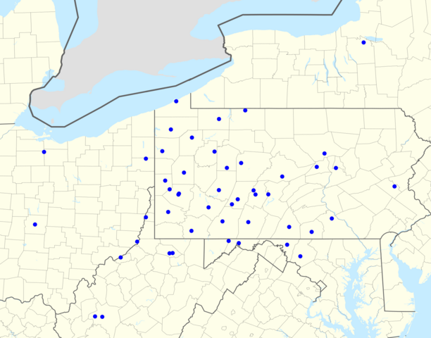
English: Steelers radio network, 2015. Not pictured: WRXZ, Myrtle Beach, SC. |
| Date | (UTC) |
| Source |
This file was derived from: USA location map - counties.svg: |
| Author |
|
| Point Maps
══▻ FAQ ◅══ ══▻ Create your own ◅══ |
Licensing
I, the copyright holder of this work, hereby publish it under the following licenses:
This file is licensed under the Creative Commons Attribution 3.0 Unported license.
- You are free:
- to share – to copy, distribute and transmit the work
- to remix – to adapt the work
- Under the following conditions:
- attribution – You must give appropriate credit, provide a link to the license, and indicate if changes were made. You may do so in any reasonable manner, but not in any way that suggests the licensor endorses you or your use.

|
Permission is granted to copy, distribute and/or modify this document under the terms of the GNU Free Documentation License, Version 1.2 or any later version published by the Free Software Foundation; with no Invariant Sections, no Front-Cover Texts, and no Back-Cover Texts. A copy of the license is included in the section entitled GNU Free Documentation License. |
You may select the license of your choice.
Original upload log
This image is a derivative work of the following images:
- File:USA New York location map.svg licensed with Cc-by-3.0, GFDL
- 2009-06-10T11:28:20Z NordNordWest 1572x1277 (597043 Bytes) {{Information |Description= {{de|Positionskarte vom Bundesstaat [[:de:New York (Bundesstaat)|New York]], [[:de:USA|USA]]}} Quadratische Plattkarte, N-S-Streckung 135 %. Geographische Begrenzung der Karte: * N: 45.3° N * S: 4
- File:USA New Jersey location map.svg licensed with Cc-by-3.0, GFDL
- 2009-06-17T19:59:27Z Alexrk2 839x1560 (259806 Bytes) enh
- 2009-06-13T18:01:16Z Alexrk 839x1560 (198653 Bytes) fixed SVG bug
- 2009-06-13T17:46:17Z Alexrk 839x1560 (246056 Bytes) == Beschreibung == {{Information |Description= {{de|Positionskarte von [[:de:New Jersey|New Jersey]], [[:de:USA|USA]]}} Quadratische Plattkarte, N-S-Streckung 130.0 %. Geographische Begrenzung der Karte: * N: 41.6° N * S: 38
- File:USA Pennsylvania location map.svg licensed with Cc-by-3.0, GFDL
- 2009-07-05T11:11:22Z Alexrk2 1201x805 (429769 Bytes) == Beschreibung == {{Information |Description= {{de|Positionskarte von [[:de:Pennsylvania|Pennsylvania]], [[:de:USA|USA]]}} Quadratische Plattkarte, N-S-Streckung 130.0 %. Geographische Begrenzung der Karte: * N: 42.7° N * S
- File:USA Delaware location map.svg licensed with Cc-by-3.0, GFDL
- 2009-06-22T10:54:18Z Alexrk2 470x800 (106507 Bytes) renderer bug
- 2009-06-22T10:39:54Z Alexrk2 470x800 (66078 Bytes) == Beschreibung == {{Information |Description= {{de|Positionskarte von [[:de:Delaware|Delaware]], [[:de:USA|USA]]}} Quadratische Plattkarte, N-S-Streckung 130.0 %. Geographische Begrenzung der Karte: * N: 40.0° N * S: 38.3°
- File:USA Maryland location map.svg licensed with Cc-by-3.0, GFDL
- 2009-06-22T11:30:38Z Alexrk2 1200x764 (463352 Bytes) fixed border
- 2009-06-22T11:23:05Z Alexrk2 1200x764 (459278 Bytes) crop height
- 2009-06-22T11:03:54Z Alexrk2 1201x955 (455501 Bytes) renderer bug
- 2009-06-22T10:42:06Z Alexrk2 800x636 (318450 Bytes) == Beschreibung == {{Information |Description= {{de|Positionskarte von [[:de:Maryland|Maryland]], [[:de:USA|USA]]}} Quadratische Plattkarte, N-S-Streckung 130.0 %. Geographische Begrenzung der Karte: * N: 40.3° N * S: 37.3°
- File:USA Virginia location map.svg licensed with Cc-by-3.0, GFDL
- 2009-07-06T18:02:25Z Alexrk2 1500x964 (963271 Bytes) resize
- 2009-06-26T16:42:40Z Alexrk2 1201x772 (966691 Bytes) == Beschreibung == {{Information |Description= {{de|Positionskarte von [[:de:Virginia|Virginia]], [[:de:USA|USA]]}} Quadratische Plattkarte, N-S-Streckung 130.0 %. Geographische Begrenzung der Karte: * N: 40.2° N * S: 35.8°
- File:USA West Virginia location map.svg licensed with Cc-by-3.0, GFDL
- 2009-07-03T15:31:49Z Alexrk2 1201x1118 (535137 Bytes) == Beschreibung == {{Information |Description= {{de|Positionskarte von [[:de:West Virginia|West Virginia]], [[:de:USA|USA]]}} Quadratische Plattkarte, N-S-Streckung 130.0 %. Geographische Begrenzung der Karte: * N: 40.8° N *
- File:USA Ohio location map.svg licensed with Cc-by-3.0, GFDL
- 2009-06-26T19:16:16Z Alexrk2 1010x1200 (465438 Bytes) == Beschreibung == {{Information |Description= {{de|Positionskarte von [[:de:Ohio|Ohio]], [[:de:USA|USA]]}} Quadratische Plattkarte, N-S-Streckung 130.0 %. Geographische Begrenzung der Karte: * N: 42.5° N * S: 38.2° N * W:
- File:USA Michigan location map.svg licensed with Cc-by-3.0, GFDL
- 2009-06-21T16:41:07Z Alexrk2 1066x1200 (657268 Bytes) Isle Royale
- 2009-06-21T11:39:57Z Alexrk2 1066x1200 (668111 Bytes) fixed borders
- 2009-06-21T11:30:04Z Alexrk2 1066x1200 (675974 Bytes) water lines
- 2009-06-21T11:21:34Z Alexrk2 1066x1200 (738759 Bytes) water lines
- 2009-06-21T11:02:31Z Alexrk2 1066x1200 (849542 Bytes) simp water polygons
- 2009-06-21T10:51:51Z Alexrk2 1066x1200 (860414 Bytes) == Beschreibung == {{Information |Description= {{de|Positionskarte von [[:de:Michigan|Michigan]], [[:de:USA|USA]]}} Quadratische Plattkarte, N-S-Streckung 140.0 %. Geographische Begrenzung der Karte: * N: 48.5° N * S: 41.5°
- File:USA Kentucky location map.svg licensed with Cc-by-3.0, GFDL
- 2009-09-03T14:45:55Z Alexrk2 1501x976 (842602 Bytes) == Beschreibung == {{Information |Description= {{de|Positionskarte von [[:de:Kentucky|Kentucky]], [[:de:USA|USA]]}} Quadratische Plattkarte, N-S-Streckung 130.0 %. Geographische Begrenzung der Karte: * N: 39.8° N * S: 35.8°
File history
Click on a date/time to view the file as it appeared at that time.
| Date/Time | Thumbnail | Dimensions | User | Comment | |
|---|---|---|---|---|---|
| current | 17:52, 20 August 2016 | | 2,040 × 1,600 (447 KB) | Magog the Ogre | 2016 update with better dots |
| 02:13, 17 August 2015 |  | 2,028 × 1,220 (373 KB) | Magog the Ogre | update | |
| 16:38, 2 February 2013 |  | 2,068 × 1,208 (555 KB) | Magog the Ogre | {{Information |Description={{en|Steelers radio network, 2012}} |Source={{Derived from|USA location map - counties.svg|display=50}} |Date=~~~~~ |Author=*USA Delaware location map.svg: Alexrk2 *[[:... |
File usage
The following pages on the English Wikipedia use this file (pages on other projects are not listed):
Global file usage
The following other wikis use this file:
- Usage on no.wikipedia.org