
Portal:World
The World Portal


The world is the totality of entities, the whole of reality, or everything that exists. The nature of the world has been conceptualized differently in different fields. Some conceptions see the world as unique while others talk of a "plurality of worlds". Some treat the world as one simple object while others analyze the world as a complex made up of parts.
In scientific cosmology, the world or universe is commonly defined as "[t]he totality of all space and time; all that is, has been, and will be". Theories of modality talk of possible worlds as complete and consistent ways how things could have been. Phenomenology, starting from the horizon of co-given objects present in the periphery of every experience, defines the world as the biggest horizon or the "horizon of all horizons". In philosophy of mind, the world is contrasted with the mind as that which is represented by the mind. Theology conceptualizes the world in relation to God, for example, as God's creation, as identical to God or as the two being interdependent. In religions, there is a tendency to downgrade the material or sensory world in favor of a spiritual world to be sought through religious practice. A comprehensive representation of the world and our place in it, as is found in religions, is known as a worldview. Cosmogony is the field that studies the origin or creation of the world while eschatology refers to the science or doctrine of the last things or of the end of the world.
In various contexts, the term "world" takes a more restricted meaning associated, for example, with the Earth and all life on it, with humanity as a whole or with an international or intercontinental scope. In this sense, world history refers to the history of humanity as a whole and world politics is the discipline of political science studying issues that transcend nations and continents. Other examples include terms such as "world religion", "world language", "world government", "world war", "world population", "world economy", or "world championship". (Full article...)
Selected articles -
-


EU protected designation of origin logo
The protected designation of origin (PDO) is a type of geographical indication of the European Union aimed at preserving the designations of origin of food-related products. The designation was created in 1992 and its main purpose is to designate products that have been produced, processed and developed in a specific geographical area, using the recognized know-how of local producers and ingredients from the region concerned.
The list below also shows other geographical indications. (Full article...) -

Painting of a turn-of-century trading fair, Hessisches Volksfest (Hessian Folk Festival), 1887, Louis Toussaint (1826–1887), Öl auf Leinwand.
Cultural globalization refers to the transmission of ideas, meanings and values around the world in such a way as to extend and intensify social relations. This process is marked by the common consumption of cultures that have been diffused by the Internet, popular culture media, and international travel. This has added to processes of commodity exchange and colonization which have a longer history of carrying cultural meaning around the globe. The circulation of cultures enables individuals to partake in extended social relations that cross national and regional borders. The creation and expansion of such social relations is not merely observed on a material level. Cultural globalization involves the formation of shared norms and knowledge with which people associate their individual and collective cultural identities. It brings increasing interconnectedness among different populations and cultures. The idea of cultural globalization emerged in the late 1980s, but was diffused widely by Western academics throughout the 1990s and early 2000s. For some researchers, the idea of cultural globalization is reaction to the claims made by critics of cultural imperialism in the 1970s and 1980s. (Full article...) -

Land management has preserved the natural characteristics of Hopetoun Falls, Australia while allowing ample access for visitors.
The natural environment or natural world encompasses all living and non-living things occurring naturally, meaning in this case not artificial. The term is most often applied to Earth or some parts of Earth. This environment encompasses the interaction of all living species, climate, weather and natural resources that affect human survival and economic activity.
The concept of the natural environment can be distinguished as components:- Complete ecological units that function as natural systems without massive civilized human intervention, including all vegetation, microorganisms, soil, rocks, the atmosphere, and natural phenomena that occur within their boundaries and their nature.
- Universal natural resources and physical phenomena that lack clear-cut boundaries, such as air, water, and climate, as well as energy, radiation, electric charge, and magnetism, not originating from civilized human actions.
In contrast to the natural environment is the built environment. Built environments are where humans have fundamentally transformed landscapes such as urban settings and agricultural land conversion, the natural environment is greatly changed into a simplified human environment. Even acts which seem less extreme, such as building a mud hut or a photovoltaic system in the desert, the modified environment becomes an artificial one. Though many animals build things to provide a better environment for themselves, they are not human, hence beaver dams, and the works of mound-building termites, are thought of as natural. (Full article...) -
Post-Kyoto negotiations refers to high level talks attempting to address global warming by limiting greenhouse gas emissions. Generally part of the United Nations Framework Convention on Climate Change (UNFCCC), these talks concern the period after the first "commitment period" of the Kyoto Protocol, which expired at the end of 2012. Negotiations have been mandated by the adoption of the Bali Road Map and Decision 1/CP.13 ("The Bali Action Plan").
UNFCCC negotiations are conducted within two subsidiary bodies, the Ad Hoc Working Group on Long-term Cooperative Action under the Convention (AWG-LCA) and the Ad Hoc Working Group on Further Commitments for Annex I Parties under the Kyoto Protocol (AWG-KP) and were expected to culminate in the United Nations Climate Change Conference taking place in December 2009 in Copenhagen (COP-15); negotiations are supported by a number of external processes, including the G8 process, a number of regional meetings and the Major Economies Forum on Energy and Climate that was launched by US President Barack Obama in March 2009. High level talks were held at the meeting of the G8+5 Climate Change Dialogue in February 2007 and at a number of subsequent G8 meetings, most recently leading to the adoption of the G8 leaders declaration "Responsible Leadership for a Sustainable Future" during the G8 summit in L´Aquila, Italy, in July 2009. (Full article...) -
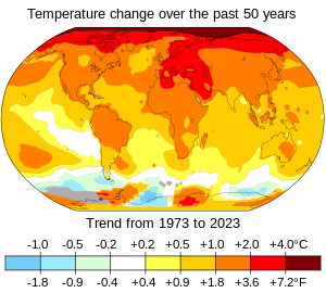
Changes in surface air temperature over the past 50 years. The Arctic has warmed the most, and temperatures on land have generally increased more than sea surface temperatures.
In common usage, climate change describes global warming—the ongoing increase in global average temperature—and its effects on Earth's climate system. Climate change in a broader sense also includes previous long-term changes to Earth's climate. The current rise in global average temperature is primarily caused by humans burning fossil fuels since the Industrial Revolution. Fossil fuel use, deforestation, and some agricultural and industrial practices add to greenhouse gases. These gases absorb some of the heat that the Earth radiates after it warms from sunlight, warming the lower atmosphere. Carbon dioxide, the primary greenhouse gas driving global warming, has grown by about 50% and is at levels unseen for millions of years.
Climate change has an increasingly large impact on the environment. Deserts are expanding, while heat waves and wildfires are becoming more common. Amplified warming in the Arctic has contributed to thawing permafrost, retreat of glaciers and sea ice decline. Higher temperatures are also causing more intense storms, droughts, and other weather extremes. Rapid environmental change in mountains, coral reefs, and the Arctic is forcing many species to relocate or become extinct. Even if efforts to minimise future warming are successful, some effects will continue for centuries. These include ocean heating, ocean acidification and sea level rise. (Full article...) -
Nuclear proliferation is the spread of nuclear weapons, fissionable material, and weapons-applicable nuclear technology and information to nations not recognized as "Nuclear Weapon States" by the Treaty on the Non-Proliferation of Nuclear Weapons, commonly known as the Non-Proliferation Treaty or NPT. Proliferation has been opposed by many nations with and without nuclear weapons, as governments fear that more countries with nuclear weapons will increase the possibility of nuclear warfare (up to and including the so-called countervalue targeting of civilians with nuclear weapons), de-stabilize international or regional relations, or infringe upon the national sovereignty of nation states.
Four countries besides the five recognized Nuclear Weapon States have acquired, or are presumed to have acquired, nuclear weapons: India, Pakistan, North Korea, and Israel. None of these four are a party to the NPT, although North Korea acceded to the NPT in 1985, then withdrew in 2003 and conducted its first nuclear test in 2006. One critique of the NPT is that the treaty is discriminatory in the sense that only those countries that tested nuclear weapons before 1968 are recognized as nuclear weapon states while all other states are treated as non-nuclear-weapon states who can only join the treaty if they forswear nuclear weapons. (Full article...) -
From Northern Antiquities, an English translation of the Prose Edda from 1847. Painted by Oluf Olufsen Bagge.
The world tree is a motif present in several religions and mythologies, particularly Indo-European, Siberian, and Native American religions. The world tree is represented as a colossal tree which supports the heavens, thereby connecting the heavens, the terrestrial world, and, through its roots, the underworld. It may also be strongly connected to the motif of the tree of life, but it is the source of wisdom of the ages.
Specific world trees include Égig érő fa in Hungarian mythology, Ağaç Ana in Turkic mythology, Kenac' Car in Armenian mythology, Modun in Mongol mythology, Yggdrasil in Norse mythology, Irminsul in Germanic mythology, the oak in Slavic, Finnish and Baltic, Jianmu (Chinese: 建木; pinyin: jiànmù) in Chinese mythology, and in Hindu mythology the Ashvattha (a Ficus religiosa). (Full article...)


General images -
-
 Machu Picchu, Inca Empire, Peru
 -

-
 Artist's rendition of an oxinated fully-frozen Snowball Earth with no remaining liquid surface water. (from History of Earth)
 -
 Great Mosque of Kairouan, Tunisia, founded 670 CE
 -
 A view of Earth with its global ocean and cloud cover, which dominate Earth's surface and hydrosphere; at Earth's polar regions, its hydrosphere forms larger areas of ice cover. (from Earth)
 -
 Olmec colossal head, now at the Museo de Antropología de Xalapa
 -
 Vitruvian Man by Leonardo da Vinci epitomizes the advances in art and science seen during the Renaissance. (from History of Earth)
 -
 A pillar at Göbekli Tepe
 -
 Peopling of the world, the Southern Dispersal scenario
 -
 Cross-section through a liposome (from History of Earth)
 -
 Angkor Wat temple complex, Cambodia, early 12th century
 -
 Geologic map of North America, color-coded by age. From most recent to oldest, age is indicated by yellow, green, blue, and red. The reds and pinks indicate rock from the Archean.
 -

-
 Artist's conception of Devonian flora (from History of Earth)
 -

-
 Notre-Dame de Paris, France
 -
 A view of Earth with different layers of its atmosphere visible: the troposphere with its clouds casting shadows, a band of stratospheric blue sky at the horizon, and a line of green airglow of the lower thermosphere around an altitude of 100 km, at the edge of space (from Earth)
 -
 A composite image of artificial light emissions at night on a map of Earth (from Earth)
 -
 The replicator in virtually all known life is deoxyribonucleic acid. DNA is far more complex than the original replicator and its replication systems are highly elaborate. (from History of Earth)
 -

-

-

-
 Earth's land use for human agriculture in 2019 (from Earth)
 -
 Tiktaalik, a fish with limb-like fins and a predecessor of tetrapods. Reconstruction from fossils about 375 million years old. (from History of Earth)
 -

-
 Graph showing range of estimated partial pressure of atmospheric oxygen through geologic time (from History of Earth)
 -
 Chennakesava Temple, Belur, India
 -
 A reconstruction of human history based on fossil data. (from History of Earth)
 -
 Artist's impression of the enormous collision that probably formed the Moon (from History of Earth)
 -
 Chloroplasts in the cells of a moss (from History of Earth)
 -
 Artist's conception of Hadean Eon Earth, when it was much hotter and inhospitable to all forms of life. (from History of Earth)
 -
 Benin Bronze head from Nigeria
 -
 A reconstruction of Pannotia (550 Ma). (from History of Earth)
 -
 Standing Buddha from Gandhara, 2nd century CE
 -
 A schematic view of Earth's magnetosphere with solar wind flowing from left to right (from Earth)
 -
 Ajloun Castle, Jordan
 -
 Persepolis, Achaemenid Empire, 6th century BCE
 -
 Pangaea was a supercontinent that existed from about 300 to 180 Ma. The outlines of the modern continents and other landmasses are indicated on this map. (from History of Earth)
 -
 A banded iron formation from the 3.15 Ga Moodies Group, Barberton Greenstone Belt, South Africa. Red layers represent the times when oxygen was available; gray layers were formed in anoxic circumstances. (from History of Earth)
 -

-
 Last Moon landing: Apollo 17 (1972)
 -
 Ming dynasty section, Great Wall of China
 -

-
 Fall of the Berlin Wall, 1989
 -
 A composite image of Earth, with its different types of surface discernible: Earth's surface dominating Ocean (blue), Africa with lush (green) to dry (brown) land and Earth's polar ice in the form of Antarctic sea ice (grey) covering the Antarctic or Southern Ocean and the Antarctic ice sheet (white) covering Antarctica. (from Earth)
 -
 Satellite time lapse imagery of Earth's rotation showing axis tilt (from Earth)
 -
 First airplane, the Wright Flyer, flew on 17 December 1903.
 -

-
 Earth's night-side upper atmosphere appearing from the bottom as bands of afterglow illuminating the troposphere in orange with silhouettes of clouds, and the stratosphere in white and blue. Next the mesosphere (pink area) extends to the orange and faintly green line of the lowest airglow, at about one hundred kilometers at the edge of space and the lower edge of the thermosphere (invisible). Continuing with green and red bands of aurorae stretching over several hundred kilometers. (from Earth)
 -
 An artist's rendering of a protoplanetary disk (from History of Earth)
 -
 The pale orange dot, an artist's impression of the early Earth which might have appeared orange through its hazy methane rich prebiotic second atmosphere. Earth's atmosphere at this stage was somewhat comparable to today's atmosphere of Titan. (from History of Earth)
 -

-
 Battle during the 1281 Mongol invasion of Japan
 -
 Empires of the world in 1898
 -
 An artist's impression of ice age Earth at glacial maximum. (from History of Earth)
 -
 Florence, birthplace of the Italian Renaissance
 -
 View of Earth from the Moon by the Lunar Reconnaissance Orbiter (from Earth)
 -

-

-
 Japanese depiction of a Portuguese carrack. European maritime innovations led to proto-globalization.
 -

-
 Image of the physical world, captured by the Hubble Space Telescope (from World)
 -
 Artist's impression of a Hadean landscape with the relatively newly formed Moon still looming closely over Earth and both bodies sustaining strong volcanism. (from History of Earth)
 -
 Shanghai. China urbanized rapidly in the 21st century.
 -
 Obelisk of Axum, Ethiopia
 -
 Change in average surface air temperature and drivers for that change. Human activity has caused increased temperatures, with natural forces adding some variability. (from Earth)
 -
 A 580 million year old fossil of Spriggina floundensi, an animal from the Ediacaran period. Such life forms could have been ancestors to the many new forms that originated in the Cambrian Explosion. (from History of Earth)
 -
 A computer-generated image mapping the prevalence of artificial satellites and space debris around Earth in geosynchronous and low Earth orbit (from Earth)
 -

-

-
 Earth's axial tilt causing different angles of seasonal illumination at different orbital positions around the Sun (from Earth)
 -
 Earth's history with time-spans of the eons to scale (from History of Earth)
 -
 Dinosaurs were the dominant terrestrial vertebrates throughout most of the Mesozoic (from History of Earth)
 -

-
 A map of heat flow from Earth's interior to the surface of Earth's crust, mostly along the oceanic ridges (from Earth)
 -
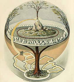
 Yggdrasil, an attempt to reconstruct the Norse world tree which connects the heavens, the world, and the underworld. (from World)
 -
 An animation of the changing density of productive vegetation on land (low in brown; heavy in dark green) and phytoplankton at the ocean surface (low in purple; high in yellow) (from Earth)
 -
 Earth's western hemisphere showing topography relative to Earth's center instead of to mean sea level, as in common topographic maps (from Earth)
 -
 An artist's impression of the Archean, the eon after Earth's formation, featuring round stromatolites, which are early oxygen-producing forms of life from billions of years ago. After the Late Heavy Bombardment, Earth's crust had cooled, its water-rich barren surface is marked by continents and volcanoes, with the Moon still orbiting Earth half as far as it is today, appearing 2.8 times larger and producing strong tides. (from Earth)
 -
Pale orange dot, an artist's impression of Early Earth, featuring its tinted orange methane-rich early atmosphere (from Earth)
-
 "Lucy", the first Australopithecus afarensis skeleton found, was only 1.06 m (3 ft 6 in) tall.
 -
 A 2012 artistic impression of the early Solar System's protoplanetary disk from which Earth and other Solar System bodies were formed (from Earth)
 -
 Tracy Caldwell Dyson, a NASA astronaut, observing Earth from the Cupola module at the International Space Station on 11 September 2010 (from Earth)
 -
 Taj Mahal, Mughal Empire, India
 -
Artist's impression of Earth during the later Archean, the largely cooled planetary crust and water-rich barren surface, marked by volcanoes and continents, features already round microbialites. The Moon, still orbiting Earth much closer than today and still dominating Earth's sky, produced strong tides. (from History of Earth)
-
 Great Pyramids of Giza, Egypt
 -
 Trilobites first appeared during the Cambrian period and were among the most widespread and diverse groups of Paleozoic organisms. (from History of Earth)
 -
 Lithified stromatolites on the shores of Lake Thetis, Western Australia. Archean stromatolites are the first direct fossil traces of life on Earth. (from History of Earth)


.jpg)


.jpg)


.svg)


.jpeg)


.jpg)


Megacities of the world -

Delhi, officially the National Capital Territory (NCT) of Delhi (ISO: Rāṣṭrīya Rājadhānī Kṣētra Dillī), is a city and a union territory of India containing New Delhi, the capital of India. Lying on both sides of the Yamuna river, but chiefly to the west, or beyond its right bank, Delhi shares borders with the state of Uttar Pradesh in the east and with the state of Haryana in the remaining directions. Delhi became a union territory on 1 November 1956 and the NCT in 1995. The NCT covers an area of 1,484 square kilometres (573 sq mi). According to the 2011 census, Delhi's city proper population was over 11 million, while the NCT's population was about 16.8 million.
Delhi's urban agglomeration, which includes the satellite cities Ghaziabad, Faridabad, Gurgaon, Noida, Greater Noida and YEIDA city located in an area known as the National Capital Region (NCR), has an estimated population of over 28 million, making it the largest metropolitan area in India and the second-largest in the world (after Tokyo). (Full article...)Did you know -

- ... that in 2017 the British travel magazine Wanderlust rated Azerbaijan's electronic visa as the easiest visa to obtain in the world?
- ... that in 1967, the world's first ATM was installed at a branch of Barclays Bank in north London?
- ... that former German chancellor Angela Merkel's grandfather likely fought against Germany in World War I?
- ... that the 2015 video game Worlds of Magic, intended as a spiritual successor to the classic game Master of Magic, failed to impress most reviewers?
- ... that Jim Laker did not become a spin bowler until he played on coconut matting strips in Egypt during World War II?
- ... that the Commission on Training Camp Activities allegedly used sexual denial to make American World War I soldiers fight harder?
- ... that The Constellation of Leo, a group portrait of people from Italy's art world, was exhibited with a note that read "not without a trace of irony"?
- ... that Trictrac was the classic tables game of France, just as backgammon is of the English-speaking world today?
Countries of the world -
.svg)
Kazakhstan, officially the Republic of Kazakhstan, is a landlocked country mostly in Central Asia, with a part in Eastern Europe. It borders Russia to the north and west, China to the east, Kyrgyzstan to the southeast, Uzbekistan to the south, and Turkmenistan to the southwest, with a coastline along the Caspian Sea. Its capital is Astana, while the largest city and leading cultural and commercial hub is Almaty. Kazakhstan is the world's ninth-largest country by land area and the largest landlocked country. It has a population of 20 million and one of the lowest population densities in the world, at fewer than 6 people per square kilometre (16 people/sq mi). Ethnic Kazakhs constitute a majority, while ethnic Russians form a significant minority. Officially secular, Kazakhstan is a Muslim-majority country, although ethnic Russians in the country form a sizeable Christian community.
Kazakhstan has been inhabited since the Paleolithic era. In antiquity, various nomadic Iranian peoples such as the Saka, Massagetae, and Scythians dominated the territory, with the Achaemenid Persian Empire expanding towards the southern region. Turkic nomads entered the region from as early as the sixth century. In the 13th century, the area was subjugated by the Mongol Empire under Genghis Khan. Following the disintegration of the Golden Horde in the 15th century, the Kazakh Khanate was established over an area roughly corresponding with modern Kazakhstan. By the 18th century, the Kazakh Khanate had fragmented into three jüz (tribal divisions), which were gradually absorbed and conquered by the Russian Empire; by the mid-19th century, all of Kazakhstan was nominally under Russian rule. Following the 1917 Russian Revolution and subsequent Russian Civil War, the territory was reorganized several times. In 1936, its modern borders were established with the formation of the Kazakh Soviet Socialist Republic within the Soviet Union. Kazakhstan was the last Soviet republic to declare independence during the dissolution of the Soviet Union from 1988 to 1991. (Full article...)Related portals
Protected areas of the world -
-
-
The Protected areas of Kyrgyzstan are regulated by the law on specially protected natural areas of 2 May 2011, last modified on 2 June 2018. In total, they cover 14,761.216 km2 (5,699.337 sq mi) and account for 7.38% of the country's total area (as of 2017). The first protected area in Kyrgyzstan (Issyk-Kul) was established in 1948. According to the Government Decree on Priorities of Conservation of Biological Diversity and the relevant Action Plan for 2014-2024 the target area for the protected areas in Kyrgyzstan is 10 percent of the country’s area by 2024.
The protected areas are subdivided into seven categories: (Full article...) -
-
Bihar is a state in East India. It is bounded by Uttar Pradesh to the west, Nepal to the north, West Bengal to the east and Jharkhand to the south. About 7% of the state is protected forest area. (Full article...)
-
The Australian Capital Territory as of 2014 contains 46 separate protected areas with a total land area of 1,302 km2 (503 sq mi) or 55.5% of the territory's area, and which managed by Territory and Municipal Services of the ACT government: (Full article...)
-

Protected areas in Tanzania (Hifahdi za Mali hai za Tanzania, in Swahili) are extremely varied, ranging from sea habitats over grasslands to the top of the Kilimanjaro, the tallest mountain in Africa. About a third of the country's total area is protected to a certain degree as a national park, game reserve, marine park, forest reserve or the like. 840 protected areas are spread across 7,330 km2 of ocean and 361,594 km2 of land in Tanzania. The coastal and marine areas are less protected than terrestrial ecosystems, which are given the highest level of protection. Tanzania is one of the world's major biodiversity hotspots thanks to its vast national parks, "the Eastern Arc" mountains, wetlands, coastal forests, marine, and freshwater systems as remarkable reservoirs of plant and animal species. A wide range of endemic species of birds, reptiles, snakes, amphibians, wild coffee variations, and the well-known African violet flower can also be found in Tanzania. (Full article...) -
As of present, there are around 400 protected areas in Pakistan that are recognized by IUCN. The total protected land area represents 13% of Pakistan's landmass as of 2020, The Government of Pakistan plans to increase it to at least 15% by 2023. As a signatory of the UN Convention on Biological Diversity, Pakistan is committed to expanding its protected areas to encompass 17% of its total territory by the year 2030. This ambitious goal aims to ensure the long-term conservation of nature, safeguard vital ecosystem services, and preserve the cultural values associated with these protected areas. (Full article...)
-
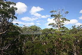
The Valley of the Giants skywalk at Walpole-Nornalup National Park
Western Australia is the second largest country subdivision in the world.
As of 2022, based on the latest Collaborative Australian Protected Areas Database report, it contains 1857 separate land-based protected areas with a total area of 76,142,710 hectares (188,152,700 acres), accounting for just over 30 percent of the state's land mass. By area, Indigenous Protected Areas account for the largest part of this, almost 67 percent while, by number, nature reserves hold the majority with two-third of all land-based protected areas being nature reserves. (Full article...) -

A family of Asiatic lions at Gir National Park
The Gujarat state of western India has four National Parks and twenty-three wildlife sanctuaries which are managed by the Forest Department of the Government of Gujarat. (Full article...) -
The following list of protected areas of British Columbia includes all federally and provincially protected areas within the Canadian province of British Columbia. As of 2015, approximately 15.46% of the province's land area and 3.17% of the province's waters are protected. (Full article...)
-
Rock carvings at the Ewaninga Rock Carvings Conservation Reserve
The protected areas of the Northern Territory consists of protected areas managed by the governments of the Northern Territory and Australia and private organisations with a reported total area of 335,527 square kilometres (129,548 sq mi) being 24.8% of the total area of the Northern Territory of Australia. (Full article...) -
"Temple Gate" Rock formation at Alkhanay National Park
Protected areas of Russia, (official Russian title: Russian: Особо охраняемые природные территории, literally "Specially Protected Natural Areas"), is governed by the corresponding 1995 law of the Russian Federation. (Full article...) -
The National Parks of Argentina make up a network of 35 national parks in Argentina. The parks cover a very varied set of terrains and biotopes, from Baritú National Park on the northern border with Bolivia to Tierra del Fuego National Park in the far south of the continent. The Administración de Parques Nacionales (National Parks Administration) is the agency that preserves and manages these national parks along with Natural monuments and National Reserves within the country.
The headquarters of the National Parks Service are in downtown Buenos Aires, on Santa Fe Avenue. A library and information centre are open to the public. The administration also covers the national monuments, such as the Jaramillo Petrified Forest, and natural and educational reserves. (Full article...) -
Protected areas of Turkmenistan include nine nature reserves (zapovednik) and 13 sanctuaries (zakaznik) with a total area of 19,750 km2 or more than 4% of Turkmenistan's territory. (Full article...)
-
Protected areas of Slovakia are areas that need protection because of their environmental, historical or cultural value to the nation. Protected areas in Slovakia are managed by institutions and organizations governed by the Ministry of the Environment.
Types of protected areas:- National Park (Slovak: Národný park; abbr. NP)
- Protected Landscape Area (Chránená krajinná oblasť; CHKO)
- National Nature Reserve (Národná prírodná rezervácia; NPR)
- Nature Reserve (Prírodná rezervácia; PR)
- National Nature Monument (Národná prírodná pamiatka; NPP)
- Nature Monument (Prírodná pamiatka; PP)
- Protected Site (Chránený areál; CHA)
- Protected Landscape Element (Chránený krajinný prvok; CHKP)
- Protected Bird Area* (Chránené vtáčie územie; CHVÚ) *Technically Special Protection Area (SPA) under the EU Bird's Directive
- Protected Tree (Chránený strom; CHS)


Selected world maps
-
 Mollweide projection of the world
 -
 United Nations Human Development Index map by country (2016)
 -
 A plate tectonics map with volcano locations indicated with red circles
 -
 Only a few of the largest large igneous provinces appear (coloured dark purple) on this geological map, which depicts crustal geologic provinces as seen in seismic refraction data
 -
 1516 map of the world by Martin Waldseemüller
 -
 Index map from the International Map of the World (1:1,000,000 scale)
 -
 The Goode homolosine projection is a pseudocylindrical, equal-area, composite map projection used for world maps.
 -
 Time zones of the world
 -
 The world map by Gerardus Mercator (1569), the first map in the well-known Mercator projection


World records
- List of Olympic records in athletics
- List of world records in athletics
- List of junior world records in athletics
- List of world records in masters athletics
- List of world youth bests in athletics
- List of IPC world records in athletics
- List of world records in canoeing
- List of world records in chess
- List of cycling records
- List of world records in track cycling
- List of world records in finswimming
- List of world records in juggling
- List of world records in rowing
- List of world records in speed skating
- List of world records in swimming
- List of IPC world records in swimming
- List of world records in Olympic weightlifting
Topics

Continents of Earth | ||||||||
|---|---|---|---|---|---|---|---|---|
| ||||||||
| ||||||||
| ||||||||


| Cenozoic Era (present–66.0 Ma) |
| ||||||||||||
|---|---|---|---|---|---|---|---|---|---|---|---|---|---|
| Mesozoic Era (66.0–252 Ma) |
| ||||||||||||
| Paleozoic Era (252–539 Ma) |
| ||||||||||||
| Proterozoic Eon (539 Ma–2.5 Ga) |
| ||||||||||||
| Archean Eon (2.5–4 Ga) | |||||||||||||
| Hadean Eon (4–4.6 Ga) | |||||||||||||
ka = kiloannum (thousands years ago); Ma = megaannum (millions years ago); Ga = gigaannum (billions years ago). See also: Geologic time scale • | |||||||||||||
| Locations | ||
|---|---|---|
| Related | ||

| |||||||||||||||||||
| |||||||||||||||||||
| |||||||||||||||||||

Economic classification of countries | |||||
|---|---|---|---|---|---|
| Three-World Model | |||||
| Gross domestic product (GDP) |
| ||||
| Gross national income (GNI) | |||||
| Wages | |||||
| Wealth | |||||
| Other national accounts | |||||
| Human development | |||||
| Digital divide | |||||
| Net international investment position (NIIP) | |||||
| Technological |
| ||||
|---|---|---|---|---|---|
| Sociological | |||||
| Ecological |
| ||||
| Biological |
| ||||
| Astronomical | |||||
| Eschatological |
| ||||
| Others |
| ||||
| Fictional | |||||
| Organizations | |||||
Categories

Wikimedia
The following Wikimedia Foundation sister projects provide more on this subject:
-
 Commons
Free media repository -
 Wikibooks
Free textbooks and manuals -
 Wikidata
Free knowledge base -
 Wikinews
Free-content news -
 Wikiquote
Collection of quotations -
 Wikisource
Free-content library -
 Wikispecies
Directory of species -
 Wikiversity
Free learning tools -
 Wikivoyage
Free travel guide -
 Wiktionary
Dictionary and thesaurus


