
File:First Space-Based View of the Ozone Hole (8006648994).jpg

Original file (911 × 932 pixels, file size: 282 KB, MIME type: image/jpeg)
| This is a file from the Wikimedia Commons. Information from its description page there is shown below. Commons is a freely licensed media file repository. You can help. |
.jpg)
Summary
| Description |
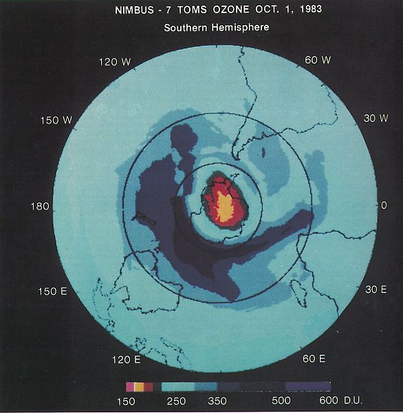
At an August 1985 meeting in Prague, atmospheric scientist Pawan Bhartia presented this satellite-based image that revealed for the first time the size and magnitude of the Antarctic ozone hole. The discovery ultimately led to the 1987 Montreal Protocol, a landmark international treaty designed to phase out ozone-depleting substances. Yesterday, Sept. 16,2012, marked 25 years since the treaty was opened for signatures. NASA satellites continue to provide clear snapshots of a generally stabilized Antarctic ozone hole as it cycles toward and away from its annual maximum depth by late September or early October. To read a Q&A about the discovery with NASA's Pawan Bhartia, visit: www.nasa.gov/topics/earth/features/bhartia-qa.html Credit: NASA NASA Goddard Space Flight Center enables NASA’s mission through four scientific endeavors: Earth Science, Heliophysics, Solar System Exploration, and Astrophysics. Goddard plays a leading role in NASA’s accomplishments by contributing compelling scientific knowledge to advance the Agency’s mission. Follow us on Twitter Like us on Facebook Find us on Instagram |
| Date | |
| Source | First Space-Based View of the Ozone Hole |
| Author | NASA Goddard Space Flight Center from Greenbelt, MD, USA |
Licensing
- You are free:
- to share – to copy, distribute and transmit the work
- to remix – to adapt the work
- Under the following conditions:
- attribution – You must give appropriate credit, provide a link to the license, and indicate if changes were made. You may do so in any reasonable manner, but not in any way that suggests the licensor endorses you or your use.
| This image was originally posted to Flickr by NASA Goddard Photo and Video at https://flickr.com/photos/24662369@N07/8006648994. It was reviewed on 17 September 2016 by FlickreviewR and was confirmed to be licensed under the terms of the cc-by-2.0. |
| This file is in the public domain in the United States because it was solely created by NASA. NASA copyright policy states that "NASA material is not protected by copyright unless noted". (See Template:PD-USGov, NASA copyright policy page or JPL Image Use Policy.) | ||
 |
Warnings:
|
File history
Click on a date/time to view the file as it appeared at that time.
| Date/Time | Thumbnail | Dimensions | User | Comment | |
|---|---|---|---|---|---|
| current | 21:32, 17 September 2016 | | 911 × 932 (282 KB) | Vanished Account Byeznhpyxeuztibuo | Transferred from Flickr via Flickr2Commons |
File usage
Global file usage
The following other wikis use this file:
- Usage on bn.wikipedia.org
- Usage on ha.wikipedia.org
- Usage on tum.wikipedia.org
.jpg)