
Portal:Devon
The Devon Portal
.jpg)
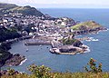
Devon (/ˈdɛvən/ DEV-ən; historically also known as Devonshire /-ʃɪər, -ʃər/ -sheer, -shər) is a ceremonial county in South West England. It is bordered by the Bristol Channel to the north, Somerset and Dorset to the east, the English Channel to the south, and Cornwall to the west. The city of Plymouth is the largest settlement, and the city of Exeter is the county town.
Devon has a varied geography. It contains Dartmoor and part of Exmoor, two upland moors which are the source of most of the county's rivers, including the Taw, Dart, and Exe. The longest river in the county is the Tamar, which forms most of the border with Cornwall and rises in the Devon's northwest hills. The southeast coast is part of the Jurassic Coast World Heritage Site, and characterised by tall cliffs which reveal the Triassic, Jurassic and Cretaceous geology of the region. The county gives its name to the Devonian geologic period, which includes the slates and sandstones of the north coast. Dartmoor and Exmoor have been designated national parks, and the county also contains, in whole or in part, five national landscapes.
In the Iron Age, Roman and the Sub-Roman periods, the county was the home of the Dumnonii Celtic Britons. The Anglo-Saxon settlement of Britain resulted in the partial assimilation of Dumnonia into the kingdom of Wessex in the eighth and ninth centuries, and the western boundary with Cornwall was set at the Tamar by king Æthelstan in 936. (Full article...)
Selected article -

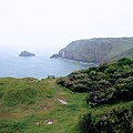
Exmoor is loosely defined as an area of hilly open moorland in west Somerset and north Devon in South West England. It is named after the River Exe, the source of which is situated in the centre of the area, two miles north-west of Simonsbath. Exmoor is more precisely defined as the area of the former ancient royal hunting forest, also called Exmoor, which was officially surveyed 1815–1818 as 18,810 acres (7,610 ha) in extent. The moor has given its name to a National Park, which includes the Brendon Hills, the East Lyn Valley, the Vale of Porlock and 55 km (34 mi) of the Bristol Channel coast. The total area of the Exmoor National Park is 692.8 km2 (267.5 sq mi), of which 71% is in Somerset and 29% in Devon.
The upland area is underlain by sedimentary rocks dating from the Devonian and early Carboniferous periods with Triassic and Jurassic age rocks on lower slopes. Where these reach the coast, cliffs are formed which are cut with ravines and waterfalls. It was recognised as a heritage coast in 1991. The highest point on Exmoor is Dunkery Beacon; at 519 metres (1,703 ft) it is also the highest point in Somerset. The terrain supports lowland heath communities, ancient woodland and blanket mire which provide habitats for scarce flora and fauna. There have also been reports of the Beast of Exmoor, a cryptozoological cat roaming Exmoor. Several areas have been designated as Nature Conservation Review and Geological Conservation Review sites.
There is evidence of human occupation from the Mesolithic. This developed for agriculture and extraction of mineral ores into the Bronze and Iron Ages. The remains of standing stones, cairns and bridges can still be identified. The royal forest was granted a charter in the 13th century, however foresters who managed the area were identified in the Domesday Book. In the Middle Ages sheep farming was common with a system of agistment licensing the grazing of livestock as the Inclosure Acts divided up the land. The area is now used for a range of recreational purposes. (Full article...)General images
-
 The gatehouse of Rougemont Castle (from Exeter)
 -
 Sir Francis Drake (from Plymouth)
 -

-
 Exeter St Davids Railway Station (from Exeter)
 -
 The Exeter Riddle Sculpture in Exeter High Street, created by artist Michael Fairfax and installed in 2005 (from Exeter)
 -
 Population pyramid of Plymouth (unitary authority) in 2021 (from Plymouth)
 -
-

-

-

-
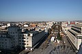
 Exeter Canal Basin (from Exeter)
 -
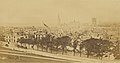
 Plymouth Drake's Island (1860s-1880s) by Francis Frith (from Plymouth)
 -
 A portion of Exeter's city wall, formed of both Roman and medieval stones (from Exeter)
 -
 The coat of arms of Devon County Council (from Devon)
 -
 The Exeter Law Courts (from Exeter)
 -
 The River Exe (from Exeter)
 -
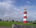 Smeaton's Tower (from Plymouth)
 -

-
 "The House That Moved", West Street, Exeter (from Exeter)
 -

-
 Remains of the medieval Exe Bridge, built around 1200 (from Exeter)
 -
 Prysten House, Finewell Street, 1498, is the oldest surviving house in Plymouth, and built from local Plymouth Limestone and Dartmoor granite (from Plymouth)
 -
 Exeter Civic Centre (from Exeter)
 -
 The High Street ca. 1895 (from Exeter)
 -

-

-
 Plymouth (1860s-1880s) by Francis Frith (from Plymouth)
 -
 Naval War Memorial (from Plymouth)
 -
 Armada Way looking north (from Plymouth)
 -

-
 Civic Centre, completed 1962, symbolic of the Post War 'Heroic Modernism' of the Welfare State; a listed building since 2007 (from Plymouth)
 -
 The Mayflower Steps Memorial (from Plymouth)
 -
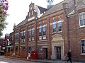
 County Hall, Exeter. Headquarters for Devon County Council. (from Devon)
 -
 Plymouth the Hoe (postcard c1920) by A.R. Quinton (from Plymouth)
 -
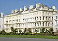 Elliot Terrace, Plymouth Hoe (from Plymouth)
 -
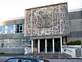
 Laver Building, University of Exeter (from Exeter)
 -
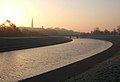 Exe Flood Relief Channel built after the floods of 1960 (from Exeter)
 -
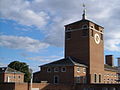
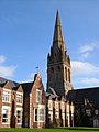 St Michael's Church and Episcopal Building (from Exeter)
 -
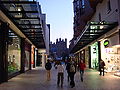 Princesshay Shopping Centre with Exeter Cathedral in the background (from Exeter)
 -
-
 Siege of Plymouth, 1643 (from Plymouth)
 -
 The New Palace Theatre in 2008 (from Plymouth)
 -
 Black-eyed Sue and Sweet Poll of Plymouth mourning their lovers, who are soon to be transported to Botany Bay, 1792 (from Plymouth)
 -
 Barnfield Theatre (from Exeter)
 -
 Geological map of Wales & Southwest England (from Devon)
 -
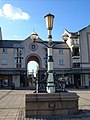
 Lamp standard from the 1905 Exe bridge, installed at Butts Ferry, on Exeter Quayside, in 1983 (from Exeter)
 -

-
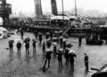 Unloading mail by hand from the Sir Francis Drake at Millbay Docks, March 1926 (from Plymouth)
 -
 Watercolour by Olive Wharry circa 1942 of St. Sidwell's Church, Exeter, after the Blitz. In the early hours of 4th May 1942 a 250kg bomb fell directly on St Sidwells. The church tower was left standing but was so badly damaged that it was pulled down shortly after. A replacement church was built on the site. From the Royal Albert Memorial Museum's collection (63/2004/4). (from Exeter)
 -
-
-
 The beach at Westward Ho!, North Devon, looking north towards the shared estuary of the rivers Taw and Torridge (from Devon)
 -
 Cliffs in Devon (from Devon)
 -
-
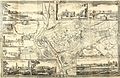 John Rocque's 1744 map of Exeter (from Exeter)
 -
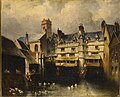
 The Higher Market, Exeter, in 1943; at this time the larger firms such as Mac Fisheries had joined the smaller shopkeepers' stalls in the market, which, before the war, along with neighbouring Goldsmith Street, was earmarked for demolition; a new Civic Centre was to be built on the site. (from Exeter)
 -

-
 An illustration of Exeter in 1563, entitled Civitas Exoniae (vulgo Excester) urbs primaria in comitatu Devoniae (from Exeter)
 -
 Grade I listed Town Hall, Column and Library in Devonport (from Plymouth)
 -

-
-
 The flag of the historic county of Devon (from Devon)
 -
 MV Pont-Aven: Brittany Ferries service to Roscoff, France and Santander, Spain in Millbay Docks (from Plymouth)
 -
 Exeter Guildhall, which dates from 1470 (from Exeter)
 -
 HMNB Devonport – the largest operational naval base in Western Europe. (from Plymouth)
 -
 the 'Invincible' Spanish Armada, 1588 (from Plymouth)
 -
 Charter map of Sutton harbour and Plymouth in 1540 (from Plymouth)
 -
 Exeter International Airport (from Exeter)
 -
 Frontispiece to Shapter's "History of the Cholera in Exeter in 1832" (from Exeter)
 -
 Roger Deakins, cinematographer (from Devon)
 -

-
 Plymouth Pavilions, home to the Plymouth City Patriots. (from Plymouth)
 -
 Population pyramid of Exeter (district) in 2021 (from Exeter)
 -
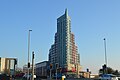 Beckley Point (from Plymouth)
 -
 The Cathedral Green after a rare snowfall (from Exeter)
 -
 Agatha Christie, best selling crime novelist (from Devon)
 -
-
 St David's Church, Exeter (from Exeter)
 -

-
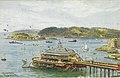
 Northeastward view of Plymouth Sound from Mount Edgcumbe Country Park in Cornwall, with Drake's Island (centre) and, behind it from left to right, the Royal Citadel, the fuel tanks of Cattedown, and Mount Batten; in the background, the hills of Dartmoor. (from Plymouth)
 -
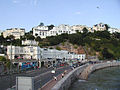
 Torquay sea front during Storm Emma – March 2018 (from Devon)
 -
 Oil on canvas painting by an unknown artist c.1870. These houses were later demolished to make way for St Edmund's Church. The painting depicts the edge of the River Exe flowing under three arches of the Old Exe Bridge, with houses on the bridge and on the river bank, St Edmund's Church can be seen in the top left. (from Exeter)
 -
 Interior of the Drake Circus Shopping Centre in 2006 (from Plymouth)
 -

-
 Plymouth the Promenade Pier (postcard c1925) by A. R. Quinton (from Plymouth)
 -
 John Lewis Building (right), adjacent to Waterstones (left) in the busy high street (from Exeter)
 -
 Inter-city trains at Plymouth station, operated by Great Western Railway (from Plymouth)


.jpg)


.jpg)


.jpg)


.jpg)


.jpg)


Selected image

Recently featured: Bigbury sea tractor - Crazywell cross - South Devon Cattle - Dartmoor tors – Plymouth harbour – Westward Ho! beach
Subcategories

Map

Related portals
Did you know...

- ... that Plymouth's lighthouse, Smeaton's Tower (pictured), was dismantled and then rebuilt on Plymouth Hoe as a memorial?
- ... that Devon is the third largest of the English counties and has a population of 1,109,900?
- ... that the name Devon derives from the name of the Celtic people who inhabited the southwestern peninsula of Britain at the time of the Roman invasion?
- ... that Devon was one of the first areas of England settled following the end of the last ice age?
- ... that the St Nicholas Priory in Exeter is being restored with the same methods that were used 500 years ago?
- ... that Devon is the only county in England to have two separate coastlines?
- ... that there was no established coat of arms for Devon until 1926?
- ... that the English Riviera Geopark in Torbay is the world's only urban Geopark?
Topics
WikiProjects

Associated Wikimedia
The following Wikimedia Foundation sister projects provide more on this subject:
-
 Commons
Free media repository -
 Wikibooks
Free textbooks and manuals -
 Wikidata
Free knowledge base -
 Wikinews
Free-content news -
 Wikiquote
Collection of quotations -
 Wikisource
Free-content library -
 Wikiversity
Free learning tools -
 Wikivoyage
Free travel guide -
 Wiktionary
Dictionary and thesaurus


