
Portal:Western Australia
Introduction
 Western Australia (commonly abbreviated as WA) is a state of Australia occupying the western third of the land area of Australia, excluding external territories. It is bounded by the Indian Ocean to the north and west, the Southern Ocean to the south, the Northern Territory to the north-east, and South Australia to the south-east. With a total land area of 2,527,013 square kilometres (975,685 sq mi), Western Australia is Australia's largest state as well as the second-largest subdivision of any country on Earth, surpassed only by the Sakha Republic in eastern Russia. the state has 2.76 million inhabitants—11 percent of the national total. The vast majority (92 percent) live in the south-west corner; 79 percent of the population lives in the Perth area, leaving the remainder of the state sparsely populated. The first Europeans to visit Western Australia belonged to the Dutch Dirk Hartog expedition, who visited the Western Australian coast in 1616. The first permanent European colony in what is today Western Australia occurred following the landing by Major Edmund Lockyer on 26 December 1826 of an expedition on behalf of the New South Wales colonial government. Lockyer established a convict-supported military garrison at King George III Sound, at present-day Albany, and on 21 January 1827 he formally took possession for the British Crown of the western part of the continent that was not already claimed by the Crown. This was followed by the establishment of the Swan River Colony in 1829, including the site of the present-day capital, Perth. (Full article...)
|


.jpg)


(Northern
Territory) |
 Good articles -
-

Collier Road is a 4.7-kilometre (2.9 mi) main road in the north-eastern suburbs of Perth, Western Australia, linking Morley in the north-west to Bassendean in the south-east. It services an industrial area in Bayswater and Bassendean, the Morley business district, and connects to Tonkin Highway. Collier Road first existed as a gravel track in the 1910s. The 1950s and 1960s saw the land around Collier Road change from rural to urban. It has undergone a major realignment twice, first in the mid-1980s to make room for a larger shopping centre in Morley, and between 2016 and 2018, for the construction of an interchange with Tonkin Highway. (Full article...) -
Frederick Benjamin Carlin (27 July 1912 – 7 March 1981) was an Australian adventurer who was the first person to circumnavigate the world in an amphibious vehicle. Born in Northam, Western Australia, Carlin attended Guildford Grammar School in Perth, and later studied mining engineering at the Kalgoorlie School of Mines. After qualifying as an engineer, he worked on the Goldfields before emigrating to China in 1939 to work in a British coal mine. In World War II, Carlin was posted to the Indian Army Corps of Engineers, serving in India, Italy, and throughout the Middle East. After his discharge from service in 1946, he emigrated to the United States with his American wife, Elinore (née Arone).
Sparked by an idea he had whilst in the military, Carlin proposed that the couple honeymoon by crossing the Atlantic Ocean in a modified Ford GPA (an amphibious version of the Ford GPW Jeep), which they named the Half-Safe. Beginning their trip in Montreal, Quebec, Canada, the Carlins finally completed the transatlantic crossing in 1951 after unsuccessful attempts. From there, they travelled to Europe, temporarily settling in Birmingham to raise more money. They resumed their journey in 1954, travelling overland through the Middle East before arriving in Calcutta. After a short fundraising trip to Australia, Carlin's wife left to return to the United States. He resumed the journey with new partners, travelling through South-East Asia and the Far East to the northern tip of Japan, and then to Alaska. After an extended tour through the United States and Canada, he and Half-Safe returned to Montreal, having travelled over 17,000 kilometres (11,000 mi) by sea and 62,000 kilometres (39,000 mi) by land during the ten-year journey. Following Carlin's death in 1981, Half-Safe was acquired by Guildford Grammar, his old school, where it remains on display. (Full article...) -
Severe Tropical Cyclone Ilona caused moderate damage across the Pilbara region of Western Australia in mid-December 1988. The system originated from a monsoon trough that coalesced into a tropical low over the Timor Sea on 12 December. The system initially moved southwest, before moving on a more westerly course. Steady intensification occurred and Ilona reached its peak strength on 17 December as a low-end severe tropical cyclone. A southward turn directed the cyclone toward Western Australia, and it made landfall near Mardie Station. The system subsequently degraded over land and dissipated on 19 December.
The cyclone's effects were relatively limited, though locally significant damage was reported in areas such as Dampier and Karratha. Several homes lost their roof and downed power lines left towns without power for several days. No casualties were reported, damage amounted to A$1 million (US$725,000), and the name Ilona was retired after the season. (Full article...) -
Tropical Cyclone Alessia was the first tropical cyclone to affect the Northern Territory of Australia in November since Cyclone Joan in 1975. The storm was first identified as a tropical low on 20 November 2013 well to the northwest of Australia. Tracking generally west to west-southwest, the small system steadily organized into a tropical cyclone by 22 November. Maintaining a small central dense overcast, Alessia brushed the Kimberley region before making landfall in the Top End region with winds of 65 km/h (40 mph) on 23 and 24 November respectively. Some weakening took place as the system moved over land; however, reorganization occurred as it neared the Gulf of Carpentaria. After moving over water on 26 November, it redeveloped gale-force winds. Alessia reached its peak intensity on 27 November with winds of 85 km/h (53 mph) and a barometric pressure of 991 mbar (hPa; 29.26 inHg) and subsequently made its final landfall near Wollogorang. Weakening ensued once more as the storm traveled over land; though, Alessia's remnants looped eastward back over water before doubling back to the west. The system was last noted moving inland again over the Northern Territory on 1 December.
Throughout Alessia's existence, it caused only minimal damage. Several areas experienced gale-force winds, with gusts measured up to 109 km/h (68 mph) on Centre Island. Moderate to heavy rains accompanied the system as well, with a storm maxima of 290.4 mm (11.43 in) also occurring on Centre Island. (Full article...) -
The Mitchell Freeway is a 41.5-kilometre-long (25.8 mi) freeway in the northern suburbs of Perth, Western Australia, linking central Perth with the city of Joondalup. It is the northern section of State Route 2, which continues south as Kwinana Freeway and Forrest Highway. Along its length are interchanges with several major roads, including the Graham Farmer Freeway and Reid Highway. The southern terminus of the Mitchell Freeway is at the Narrows Bridge, which crosses the Swan River, and the northern terminus is at Romeo Road in Alkimos.
Planning for the route began in the 1950s, and the first segment in central Perth was constructed between 1967 and 1973. Named after Sir James Mitchell, the freeway has been progressively extended north since then. In the 1970s, the first two extensions were completed, up to Hutton Street in Osborne Park. By the end of the 1980s, the freeway had reached Ocean Reef Road in Edgewater. The Joondalup railway line was constructed in the freeway median in the early 1990s. This necessitated the relocation of a section of the southbound carriageway, and the construction of three new bridges. In conjunction with these works, additional lanes were constructed in the realigned section. (Full article...) -
Bayswater is a suburb 6 kilometres (4 mi) north-east of the central business district (CBD) of Perth, the capital of Western Australia. It is just north of the Swan River, within the City of Bayswater local government area. It is predominantly a low-density residential suburb consisting of single-family detached homes. However, there are several clusters of commercial buildings, most notably in the suburb's town centre, around the intersection of Whatley Crescent and King William Street and a light industrial area in the suburb's east.
Prior to European settlement, the Mooro group of the Whadjuk Noongar people inhabited the area. In 1830, the year after the European settlement of the Swan River Colony, land along the river was divided between the colonists, who moved in soon after. Most either died or left in the months following, leaving the area undeveloped for most of the 19th century. In 1881, the Fremantle–Guildford railway line was built, triggering the founding of the Bayswater Estate, the first development in the area, and in 1897, the Bayswater Road Board was founded, giving Bayswater its own local government. At first, development consisted of nurseries, market gardens and dairies, but as time went on, Bayswater became more and more suburban. Today, Bayswater is fully suburbanised, with the subdividing of older lots being commonplace. Plans for apartments around Bayswater and Meltham railway stations are a contentious issue. (Full article...) -
The West Coast Eagles are an Australian rules football team based in Perth, Western Australia. Their 2019 season was their 33rd season in the Australian Football League (AFL), their sixth season under coach Adam Simpson, and their fifth and final season with Shannon Hurn as captain. Having won the 2018 AFL Grand Final, expectations were that West Coast would finish in the top four on the ladder. They won only three of their first six games, losing by greater than 40 points to the Brisbane Lions, Port Adelaide and Geelong, placing the Eagles 12th on the ladder at the end of round six. They then won 12 of their next 14 games, the losses being to Sydney by 45 points and to Collingwood by 1 point. By the end of round 21, West Coast had been in the top four since round 14, and were aiming to finish in the top two. They then had a disappointing six-point loss to Richmond, and a shock 38-point loss to Hawthorn at home, to finish the season fifth on the ladder. This meant West Coast missed out on the double chance that top four teams get in the AFL finals, significantly lowering their chances of winning the Grand Final. In the 2019 AFL finals series, they faced Essendon in an elimination final, beating them by 55 points, before losing to Geelong in a semi-final by 20 points, ending West Coast's season.
Notable events include Daniel Venables suffering a career-ending concussion in round nine, Nic Naitanui returning from injury in round 15, having been out since round 17, 2018, and Willie Rioli being provisionally suspended before the semi-final after tampering with a drug test. Jack Darling, who kicked 59 goals, was the club's leading goal-scorer for the third time in his career. Darling, Hurn, Jeremy McGovern and Elliot Yeo were selected for the 2020 All-Australian team. Liam Ryan won Mark of the Year for a mark he took in round nine against Melbourne. Luke Shuey was West Coast's best and fairest player, winning the John Worsfold Medal. West Coast fielded a reserves team in the West Australian Football League for the first time in 2019. (Full article...) -
North West Coastal Highway is a generally north-south Western Australian highway which links the coastal city of Geraldton with the town of Port Hedland. The 1,300-kilometre-long (808 mi) road, constructed as a sealed two-lane single carriageway, travels through remote and largely arid landscapes. Carnarvon is the only large settlement on the highway, and is an oasis within the harsh surrounding environment. The entire highway is allocated National Route 1, part of Australia's Highway 1, and parts of the highway are included in tourist routes Batavia Coast Tourist Way and Cossack Tourist Way. Economically, North West Coastal Highway is an important link to the Mid West, Gascoyne and Pilbara regions, supporting the agricultural, pastoral, fishing, and tourism industries, as well as mining and offshore oil and gas production.
In Geraldton, the highway begins at a grade separated interchange with Brand Highway and roads providing access to the port and town centre. Two major roads link the North West Coastal Highway to the inland Great Northern Highway: Geraldton–Mount Magnet Road in Geraldton, and Nanutarra Munjina Road at Nanutarra, 845 kilometres (525 mi) further north. Several roads link provide access to coastal towns and attractions, including Shark Bay Road, Onslow Road and Karratha Road. With few towns on the highway, roadhouses are the only settlements for long stretches. North West Coastal Highway ends at Great Northern Highway, 30 kilometres (19 mi) out from Port Hedland. (Full article...) -
The First Commonwealth Paraplegic Games were held in Perth, Western Australia, from 10 to 17 November 1962. These Games preceded the 1962 British Empire and Commonwealth Games which were held in Perth from 22 November to 1 December of that year. The Commonwealth Paraplegic Games were conceived by George Bedbrook after Perth won the right to host the Commonwealth Games. Great support was received from Royal Perth Hospital, a leading spinal rehabilitation centre in Australia.
These games raised the profile of paraplegic (spinal cord and polio) athletes in Australia, particularly Western Australia. The chairman of the Organising Committee, Hugh Leslie, who had lost a leg in World War II, gave a speech aimed to change public perceptions about disabilities by addressing the power of language. These games, he told the audience, "were designed to prove to the public that the person who was bodily handicapped was not a cripple, and he hoped that that horrible word would eventually be wiped out of use. He had a slogan which he hoped would be adopted by all disabled: 'I can, I will'". (Full article...) -
Lakelands railway station is a railway station along the Mandurah line on the Transperth network in Western Australia. The station is in the Mandurah suburb of Lakelands, 6.5 kilometres (4.0 mi) north of Mandurah station and 64.5 kilometres (40.1 mi) south of Perth Underground station. Construction started in 2021 and it opened on 11 June 2023.
Provisions for the station were made when the Mandurah line was originally built during the 2000s. There were several proposals to build the station during the 2010s, but when the state Labor Party came to power in 2017, it had committed to build the nearby Karnup station but not Lakelands station. Meanwhile, the federal Liberal Party wanted to build Lakelands station, so it committed to funding 80% of the A$80 million required to build the station. The federal government refused requests for the funding to be transferred to the Karnup station project, therefore that project was put on hold so that the state could fund Lakelands station. This resulted in accusations that the federal government was pork barrelling as Lakelands station was in Liberal MP Andrew Hastie's seat whereas Karnup station was in a safe Labor seat held by Madeleine King. (Full article...) -
Daglish is a small western suburb of Perth, the capital of Western Australia. It is approximately 4 kilometres (2.5 mi) west of the Perth central business district, and within the City of Subiaco local government area. It was named after Henry Daglish, who was the mayor of Subiaco, member for the electoral district of Subiaco and premier of Western Australia from 1904 to 1905. The Daglish railway station opened in 1924 in response to population growth in the neighbouring suburb of Subiaco. The following year, the Municipality of Subiaco bought the land west of the railway station to sell for housing. Development occurred over the following 20 years. The initial development next to the railway station used the garden suburb principles, with large lots and gardens, curved streets, and lots of green space. Today, the suburb has significant heritage value due to its uniform streetscape, with most original homes still standing. It has a population of 1,419 as of the 2016 Australian census. (Full article...) -
Carlisle railway station is a temporarily-closed suburban railway station on the Transperth network in Western Australia. It is in the Perth suburbs of Carlisle and East Victoria Park, and was predominantly served by Thornlie line services prior to its closure in November 2023.
The station first opened in July 1912. It was known as Mint Street station at first, but it was renamed Victoria Park East station in October 1912 and to its present name in May 1919. It gained a station master in 1922, which lasted until 1971. Carlisle station had minor upgrades from 2002 to 2003 in preparation for the opening of the Thornlie line, which happened in 2005. Since 20 November 2023, the station has been closed to undergo a complete rebuild as an elevated station as part of the Victoria Park-Canning Level Crossing Removal Project to remove a nearby level crossing. The station and line are planned to reopen in mid-2025. (Full article...) -
Benjamin John Small (born 11 June 1988) is an Australian politician. He was selected to serve as a senator for Western Australia, representing the Liberal Party, to fill a casual vacancy following Mathias Cormann's resignation. His first term lasted from November 2020 until his April 2022 resignation, and he resumed his term in May after being nominated to replace himself. Small was unsuccessful in his re-election bid in the 2022 federal election and his term as senator concluded on 30 June 2022.
Small studied nautical science, marine operations, and business management. He worked in marine transport and logistics for several energy and resource companies, with his holdings in those criticised as a potential conflict of interest. Before becoming a senator, he was active in grassroots politics, and unsuccessfully attempted to enter parliament at the 2016 election. Ideologically, he was considered a member of the National Right faction of the parliamentary Liberal Party. (Full article...) -
On 26 June 1950, a Douglas DC-4 Skymaster aircraft departed from Perth, Western Australia, for an eight-hour flight to Adelaide, South Australia. It crashed 22 minutes after take-off, 35 miles (56 km) east of Perth Airport. All 29 occupants were killed in the accident; one initially survived, but died six days later. It was the worst civil aviation accident in Australia.
As the aircraft flew eastwards over the outer suburbs of Perth numerous witnesses observed that it was flying at a lower altitude than usual for the daily Skymaster services, and at least one of the engines was running roughly and backfiring at regular intervals. In the minutes before it crashed, witnesses heard a number of different engine noises – sometimes operating normally, sometimes all engine noise ceased, only to be replaced by what was described as a very loud, high-pitched "scream". When the wrecked engines were examined many weeks after the accident a significant amount of corrosion product was found in the fuel system within two of the engines. After a preliminary investigation, Investigators from the Department of Civil Aviation believed the water responsible for the corrosion was also responsible for rough running of at least one engine, and ultimately temporary loss of power from all engines on at least one occasion. The investigators did not find a likely source for the water. (Full article...) -
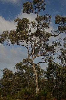
Eucalyptus wandoo, commonly known as wandoo, dooto, warrnt or wornt and sometimes as white gum, is a small to medium-sized tree that is endemic to the southwest of Western Australia. It has smooth bark, lance-shaped adult leaves, flower buds in groups of nine to seventeen, white flowers and conical to cylindrical fruit. It is one of a number of similar Eucalyptus species known as wandoo.
E. wandoo was first described in 1934 by the Australian botanist William Faris Blakely in his book A Key to the Eucalypts using material collected by the English collector Augustus Frederick Oldfield from a sand plain along the Kalgan River. , Plants of the World Online lists Eucalyptus redunca var. elata as a taxonomic synonym of E. wandoo. (Full article...)


Did you know (auto-generated)

- ... that Bill Dunn, an Indigenous Australian pastoralist approaching retirement, sold his station at half-price to the Jigalong community despite receiving full-price offers from non-Indigenous people?
- ... that Nick Goiran, a member of the Western Australian Legislative Council, proposed 357 amendments to a voluntary assisted dying bill?
- ... that Mertome Village in Bayswater, Western Australia was the first aged care complex to be built by a local government in Australia?
- ... that the search for a lost radioactive capsule along a 1,400-kilometre (870 mi) stretch of road in Western Australia was likened to looking for a needle in a haystack?
- ... that politician John D'Orazio helped to secure a three-year trial of daylight saving time in Western Australia?
- ... that Western Australia was the second Australian state to legalise voluntary assisted dying?
Categories

More portals
More did you know...

- ...that when the 1987 America's Cup was raced off Fremantle, Western Australia it was the first time for 132 years that the regatta had not been hosted by the New York Yacht Club?
- ...that the original Victoria Dam, constructed in 1891, was the first dam in Western Australia, and it stood for almost 100 years before being replaced with the current dam?
- ...that Anglican bishop Kay Goldsworthy was consecrated as the first woman bishop of any Australian church on 22 May 2008?
Related WikiProjects

Things you can do
Here are some tasks you can do to help with WikiProject Western Australia:
Associated Wikimedia
The following Wikimedia Foundation sister projects provide more on this subject:
-
 Commons
Free media repository -
 Wikibooks
Free textbooks and manuals -
 Wikidata
Free knowledge base -
 Wikinews
Free-content news -
 Wikiquote
Collection of quotations -
 Wikisource
Free-content library -
 Wikispecies
Directory of species -
 Wikiversity
Free learning tools -
 Wikivoyage
Free travel guide -
 Wiktionary
Dictionary and thesaurus


