Following the prehistoric breakup of the supercontinentGondwana, Madagascar split from Africa during the Early Jurassic, around 180 million years ago, and split from the Indian subcontinent around 90 million years ago, allowing native plants and animals to evolve in relative isolation; consequently, it is a biodiversity hotspot and one of the world's 17 megadiverse countries, with over 90% of wildlife being endemic. The island has a subtropical to tropical maritime climate. Madagascar was first settled during or before the mid-first millennium AD by Austronesian peoples, presumably arriving on outrigger canoes from present-day Indonesia. These were joined around the ninth century AD by Bantu migrants crossing the Mozambique Channel from East Africa. Other groups continued to settle on Madagascar over time, each one making lasting contributions to Malagasy cultural life. Consequently, there are 18 or more classified peoples of Madagascar, the most numerous being the Merina of the central highlands.
Until the late 18th century, the island of Madagascar was ruled by a fragmented assortment of shifting sociopolitical alliances. Beginning in the early 19th century, most of it was united and ruled as the Kingdom of Madagascar by a series of Merina nobles. The monarchy was ended in 1897 by the annexation by France, from which Madagascar gained independence in 1960. The country has since undergone four major constitutional periods, termed republics, and has been governed as a constitutional democracy since 1992. Following a political crisis and military coup in 2009, Madagascar underwent a protracted transition towards its fourth and current republic, with constitutional governance being restored in January 2014. (Full article...)
This is a Featured article, which represents some of the best content on English Wikipedia..
Marojejy Massif and the surrounding forests
Marojejy National Park (/məˈroʊdʒɛdʒiː/) is a national park in the Sava region of northeastern Madagascar. It covers 55,500 ha (214 sq mi) and is centered on the Marojejy Massif, a mountain chain that rises to an elevation of 2,132 m (6,995 ft). Access to the area around the massif was restricted to research scientists when the site was set aside as a strict nature reserve in 1952. In 1998, it was opened to the public when it was converted into a national park. It became part of the World Heritage Site known as the Rainforests of the Atsinanana in 2007. "Unique in the world, a place of dense, jungly rainforests, sheer high cliffs, and plants and animals found nowhere else on earth", Marojejy National Park has received plaudits in the New York Times and Smithsonian Magazine for its natural beauty and rich biodiversity that encompasses critically endangered members of the silky sifaka. To that end, a global consortium of conservation organizations, including the Lemur Conservation Foundation, Duke Lemur Center and Madagascar National Parks, have sought to promote research and conservation programs in Marojejy National Park, neighboring Anjanaharibe-Sud Reserve and Antanetiambo Private Reserve, to protect the endemic flora and fauna that reside in northeastern Madagascar. In addition, these organizations have implemented a variety of community-based initiatives to mitigate human encroachment on the park, such as poaching and selective logging, by encouraging local communities to engage in afforestation and silvicultural initiatives to promote a sustainable alternative to mining, slash-and-burn agriculture, and wood collection.
The wide range of elevations and rugged topography of the massif create diverse habitats that transition quickly with changes in altitude. Warm, dense rainforest can be found at lower elevations, followed by shorter forests at higher elevations, followed still by cloud forest, and topped near the peaks with the only remaining undisturbed mountain scrub in Madagascar. Better growing conditions for plants can be found on the eastern side of the mountains, which receives more rain than the western side. This habitat diversity lends itself to high levels of biodiversity. At least 118 species of bird, 148 species of reptile and amphibian, and 11 species of lemur are known to occur within Marojejy National Park. One of the lemurs, the silky sifaka (Propithecus candidus) is listed among "The World's 25 Most Endangered Primates". The helmet vanga (Euryceros prevostii) is considered the iconic bird species of the park. (Full article...)
Andriantsimitoviaminandriandehibe ("the noble without equal among great nobles") was the King of Imerina in the central highlands of Madagascar from 1650 to 1670. He acceded to the throne on the death of his father, King Andriantsitakatrandriana. He had three wives: Ratompoimbahoaka of Ambohimalaza, Princess Ramahafoloarivo (granddaughter of King Andrianjaka), and Princess Rafaravavy Rampanananiamboninitany. He is responsible for establishing the rice paddies of the Betsimitatatra that lie to the west of Ankadimbahoaka. (Full article...)
This is a Good article, an article that meets a core set of high editorial standards.
Eline at peak intensity during landfall in Mozambique on 22 February
Intense Tropical Cyclone Leon–Eline was the second longest-lived cyclone in the Indian Ocean, behind Cyclone Freddy, traveling over 11,000 km (6,800 mi) during its 29-day track through the Indian Ocean, throughout the month of February. The cyclone formed on 1 February 2000, in the Australian basin as Tropical Cyclone Leon, and was renamedEline after crossing 90° E into the South-West Indian Ocean; there, the Météo-France office in Réunion (MFR) tracked the storm's movement and intensity. Late on 17 February, Eline made landfall near Mahanoro, Madagascar, with 10‑minute winds of 165 km/h (103 mph). The storm rapidly weakened over land, but restrengthened in the Mozambique Channel to reach peak 10‑minute winds of 185 km/h (115 mph), making it an intense tropical cyclone. On 22 February, Eline made landfall about 80 km (50 mi) south of Beira, Mozambique, near peak intensity. Eline quickly weakened over land as it moved across Southern Africa, finally dissipating over eastern Namibia on 29 February.
While moving across much of the Indian Ocean, Eline brought high waves, gusty winds, and rainfall to several islands. When Eline struck Madagascar, the country was in the midst of a cholera epidemic that killed over 1,000 people. Eline directly killed at least 64 people in the country. Tropical Storm Gloria struck Madagascar 13 days later, compounding the damage and making it difficult to discern the individual effects. Damage from Eline was estimated at $9 million (USD), and collectively the two storms killed 205 people and left another 10,000 homeless. In the region around Vatomandry where Eline made landfall, 65% of houses were damaged, 90% of crops were lost, and 75% of health facilities were wrecked. (Full article...)
Image 3Toy animals made from raffia, a native palm (from Madagascar)
Image 4A street vendor selling fresh potato chips and traditional kaka pizon snacks (from Culture of Madagascar)
Image 5Men in an Outrigger Canoe Headed for Shore, an oil painting by Arman Manookian depicting the Vezo people, c. 1929 (from History of Madagascar)
Image 6Historical change in per capita GDP of Madagascar since 1950 (from Madagascar)
Image 7Rex and Riz cinemas in Antananarivo, Madagascar. (from Culture of Madagascar)
Image 8Malagasy Embassy to Europe in 1863. Left to right: Rainifiringa Ralaimaholy, Rev. John Duffus and Rasatranabo aka Rainandrianandraina. (from History of Madagascar)
Image 9Moraingy is a traditional martial art of Madagascar. (from Madagascar)
Image 10Matatana, represented in a picture of 1613, regarding a settlement of the beginning of the 16th century, in the Book of Humberto Leitão" (from Madagascar)
Image 13Mahafaly tomb with traditional painted decoration (from Culture of Madagascar)
Image 14Radama I, the first monarch of the kingdom unified central Madagascar. (from History of Madagascar)
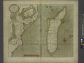
Image 15Map of Madagascar and the western portion of the East Indies, circa 1702–1707 (from History of Madagascar)
Image 16Canoe-sarcophagus of the Dayak: a burial that recalls the Malagasy tradition that former Ntaolo Vazimba and Vezo buried their dead in canoe-sarcophagi in the sea or in a lake (from History of Madagascar)
Image 17A Sumatran village showing several traditional houses (Malagasy levu). The vahoaka ntaolo villages of Madagascar were probably similar in the first millennium AD. This model is still currently present on every coast and in the remote inland areas and forests. (from History of Madagascar)
Image 21Vaγimba- "Those of the forest" in Proto–Southeast Barito, the reconstructed ancestor of the Southeast Barito languages, which includes the languages spoken by the Dayak peoples of the Barito River in Borneo. (from History of Madagascar)
Image 33The ring-tailed lemur is one of over 100 known species and subspecies of lemur found only in Madagascar. (from Madagascar)
Image 34An Austronesian outrigger canoe; Malagasy vahoaka "people" is from Proto-Malayo-Polynesian*va-waka "people of the canoe". The Vahoaka Ntaolo, the first Austronesian ancestors of the Malagasy, probably used similar canoes to reach the great island from the Sunda Islands (from History of Madagascar)
Image 35Landing of the 40th Battaillon de Chasseur à Pieds in Majunga, between 5 May and 24 May 1895. (from History of Madagascar)
Image 36A news stand in Antananarivo (from Madagascar)
Image 38National monument in Moramanga commemorating the beginning of the Malagasy Uprising on 29 March 1947. Between 11,000 and 90,000 Malagasy died during the uprising which lasted nearly two years. (from Madagascar)
Image 39The taro (saonjo in Malagasy) is, according to an old Malagasy proverb, "the elder of the rice" (Ny saonjo no zokin'ny vary), and was also a staple diet for the proto-Austronesians (from History of Madagascar)


_Madagascar.jpg)


.jpg)


.jpg)


.jpg)